Geolocate

South Heath topographic map

Click on the map to display elevation.

About this map

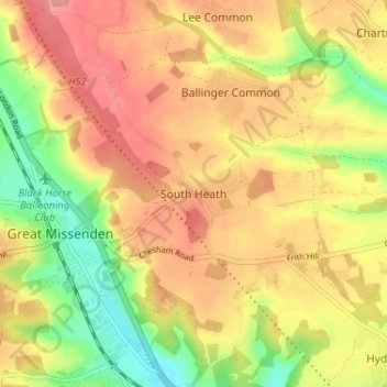
Name: South Heath topographic map, elevation, terrain.

Location: South Heath, Buckinghamshire, England, HP16 0QZ, United Kingdom (51.68877 -0.70637 51.72877 -0.66637)

Average elevation: 169 m

Minimum elevation: 115 m

Maximum elevation: 210 m

Other topographic maps

Click on a map to view its topography, its elevation and its terrain.

Chilterns National Landscape

United Kingdom > England > Buckinghamshire

The highest point is at 267 m (876 ft.) above sea level at Haddington Hill near Wendover in Buckinghamshire; a stone monument marks the summit. The nearby Ivinghoe Beacon is a more prominent hill, although its altitude is only 249 m (817 ft.). It is the starting point of the Icknield Way Path and the Ridgeway…

Average elevation: 102 m

High Wycombe

United Kingdom > England > Buckinghamshire

Average elevation: 124 m

Turville

United Kingdom > England > Buckinghamshire

Average elevation: 143 m

High Wycombe

United Kingdom > England > Buckinghamshire

Average elevation: 124 m

Chilterns National Landscape

United Kingdom > England > Buckinghamshire

The highest point is 267 m (876 ft.) above sea level at Haddington Hill near Wendover in Buckinghamshire; a stone monument marks the summit. The nearby Ivinghoe Beacon is a more prominent hill, although its altitude is only 249 m (817 ft.). It is the starting point of the Icknield Way Path and the Ridgeway…

Average elevation: 102 m

Stoke Poges

United Kingdom > England > Buckinghamshire

Average elevation: 59 m

Brill

United Kingdom > England > Buckinghamshire > Brill

Average elevation: 104 m

Aylesbury

United Kingdom > England > Buckinghamshire

Aylesbury is immediately southeast of the upper River Thame that flows past Thame to Dorchester on Thames and is partly sited on the two northernmost outcrops of Portland stone in England bisected by a small stream, Bear Brook which gives a relatively prominent position in relation to the terrain of all near,…

Average elevation: 85 m

Hoggeston

United Kingdom > England > Buckinghamshire

Average elevation: 121 m

Hazlemere

United Kingdom > England > Buckinghamshire

Average elevation: 165 m

Buckingham

United Kingdom > England > Buckinghamshire

Average elevation: 99 m

High Wycombe

United Kingdom > England > Buckinghamshire

Average elevation: 125 m

Buckingham

United Kingdom > England > Buckinghamshire

Average elevation: 99 m

Lacey Green

United Kingdom > England > Buckinghamshire

Average elevation: 177 m

Thornborough

United Kingdom > England > Buckinghamshire

Average elevation: 98 m

Bradenham

United Kingdom > England > Buckinghamshire

Average elevation: 153 m

Addington

United Kingdom > England > Buckinghamshire > Addington

Average elevation: 92 m

Creslow

United Kingdom > England > Buckinghamshire

Average elevation: 118 m

Edgcott

United Kingdom > England > Buckinghamshire

Average elevation: 71 m

Aylesbury

United Kingdom > England > Buckinghamshire

Aylesbury is immediately southeast of the upper River Thame that flows past Thame to Dorchester on Thames and is partly sited on the two northernmost outcrops of Portland stone in England bisected by a small stream, Bear Brook which gives a relatively prominent position in relation to the terrain of all near,…

Average elevation: 85 m

Seer Green

United Kingdom > England > Buckinghamshire

Average elevation: 106 m

Dunton

United Kingdom > England > Buckinghamshire

Average elevation: 127 m

Wendover

United Kingdom > England > Buckinghamshire

Average elevation: 179 m

The Rye

United Kingdom > England > Buckinghamshire > High Wycombe

Average elevation: 110 m

High Wycombe

United Kingdom > England > Buckinghamshire

Average elevation: 125 m

Stowe

United Kingdom > England > Buckinghamshire

Average elevation: 126 m

Ivinghoe

United Kingdom > England > Buckinghamshire

Average elevation: 133 m

East Claydon

United Kingdom > England > Buckinghamshire

Average elevation: 101 m

Granborough

United Kingdom > England > Buckinghamshire

Average elevation: 99 m

Hedsor

United Kingdom > England > Buckinghamshire

Average elevation: 56 m

Slapton

United Kingdom > England > Buckinghamshire > Slapton

Average elevation: 93 m

Wooburn

United Kingdom > England > Buckinghamshire

Average elevation: 74 m

Hillesden

United Kingdom > England > Buckinghamshire

Average elevation: 95 m

High Wycombe

United Kingdom > England > Buckinghamshire

Average elevation: 125 m

Swanbourne

United Kingdom > England > Buckinghamshire

Average elevation: 118 m

Wing

United Kingdom > England > Buckinghamshire > Wing

Average elevation: 121 m

Chartridge

United Kingdom > England > Buckinghamshire

Average elevation: 163 m

Lane End

United Kingdom > England > Buckinghamshire

Average elevation: 145 m

Shalstone

United Kingdom > England > Buckinghamshire

Average elevation: 123 m

Aylesbury

United Kingdom > England > Buckinghamshire

Aylesbury is immediately southeast of the upper River Thame that flows past Thame to Dorchester on Thames and is partly sited on the two northernmost outcrops of Portland (lime)stone in England bisected by a small stream, Bear Brook which gives a relatively prominent position in relation to the terrain of all…

Average elevation: 85 m

Halton

United Kingdom > England > Buckinghamshire

Average elevation: 148 m

Downley

United Kingdom > England > Buckinghamshire

Average elevation: 143 m

Watermead

United Kingdom > England > Buckinghamshire

Average elevation: 82 m

Edgcott

United Kingdom > England > Buckinghamshire

Average elevation: 71 m

Aylesbury

United Kingdom > England > Buckinghamshire

Aylesbury is immediately southeast of the upper River Thame that flows past Thame to Dorchester on Thames and is partly sited on the two northernmost outcrops of Portland (lime)stone in England bisected by a small stream, Bear Brook which gives a relatively prominent position in relation to the terrain of all…

Average elevation: 85 m

Maids Moreton

United Kingdom > England > Buckinghamshire

Average elevation: 105 m

Thornton

United Kingdom > England > Buckinghamshire

Average elevation: 89 m

Nash

United Kingdom > England > Buckinghamshire > Nash

Average elevation: 109 m

Winslow

United Kingdom > England > Buckinghamshire

Average elevation: 103 m

Beachampton

United Kingdom > England > Buckinghamshire

Average elevation: 83 m

Whaddon

United Kingdom > England > Buckinghamshire > Whaddon

Average elevation: 114 m

Weedon

United Kingdom > England > Buckinghamshire

Average elevation: 88 m

Woodham

United Kingdom > England > Buckinghamshire

Average elevation: 77 m

Tingewick

United Kingdom > England > Buckinghamshire

Average elevation: 109 m

Seer Green

United Kingdom > England > Buckinghamshire

Average elevation: 105 m

Ashley Green

United Kingdom > England > Buckinghamshire

Average elevation: 155 m

Biddlesden

United Kingdom > England > Buckinghamshire

Average elevation: 132 m

Bierton

United Kingdom > England > Buckinghamshire

Average elevation: 85 m

Amersham

United Kingdom > England > Buckinghamshire

Average elevation: 137 m

Brill

United Kingdom > England > Buckinghamshire

Average elevation: 104 m

Aylesbury

United Kingdom > England > Buckinghamshire

Aylesbury is immediately southeast of the upper River Thame that flows past Thame to Dorchester on Thames and is partly sited on the two northernmost outcrops of Portland (lime)stone in England bisected by a small stream, Bear Brook which gives a relatively prominent position in relation to the terrain of all…

Average elevation: 85 m