
Thank you for supporting this site ❤️
Make a donation
Make a donation
Sokobanja topographic map
Click on the map to display elevation.
Thank you for supporting this site ❤️
Make a donation
Make a donation
Sokobanja
Artificial Lake Bovan on the Moravica is situated some 10 minutes drive to the west of Sokobanja. Sokobanja is on elevation of about 369 m, although some parts of the town are on higher elevation.
Thank you for supporting this site ❤️
Make a donation
Make a donation
About this map
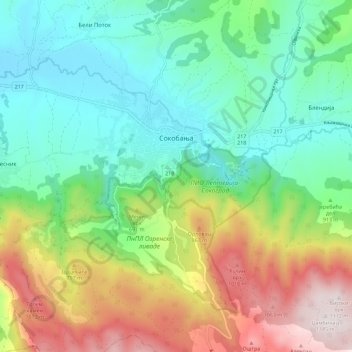
Name: Sokobanja topographic map, elevation, terrain.
Average elevation: 571 m
Minimum elevation: 270 m
Maximum elevation: 1,172 m
Thank you for supporting this site ❤️
Make a donation
Make a donation