
Thank you for supporting this site ❤️
Make a donation
Make a donation
Liewellyn Corners topographic map
Click on the map to display elevation.
Thank you for supporting this site ❤️
Make a donation
Make a donation
About this map
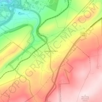
Name: Liewellyn Corners topographic map, elevation, terrain.
Average elevation: 449 m
Minimum elevation: 230 m
Maximum elevation: 615 m
Thank you for supporting this site ❤️
Make a donation
Make a donation
Other topographic maps
Click on a map to view its topography, its elevation and its terrain.
Pinchot State Forest
United States > Pennsylvania > Luzerne County > Bear Creek Township
Average elevation: 409 m