
Make a donation
Borski topographic map
Click on the map to display elevation.
Make a donation
About this map
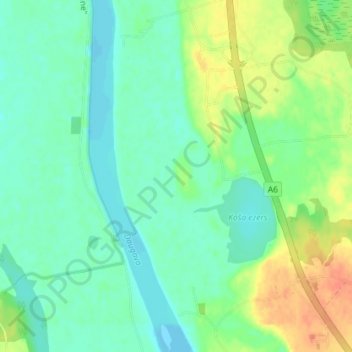
Name: Borski topographic map, elevation, terrain.
Location: Borski, Augšdaugavas novads, Latvia (55.99694 26.34889 56.03694 26.38889)
Average elevation: 96 m
Minimum elevation: 83 m
Maximum elevation: 122 m
Make a donation
Other topographic maps
Click on a map to view its topography, its elevation and its terrain.
Iecava
Iecava is situated in Bauska Municipality, within the historical Semigallia (Zemgale) region of southern Latvia, approximately 40 kilometers south of the capital Riga and 23 kilometers north of Bauska. The settlement lies along the Via Baltica (European route E67) highway, which connects it to major transport…
Average elevation: 21 m
Make a donation
Make a donation
Alūksne
Alūksne (German: Marienburg) is a town on the shores of Lake Alūksne in the Vidzeme region of Latvia near the borders with Estonia and Russia. It is the seat of the Alūksne municipality. Alūksne is the highest elevated Latvian city, located in East Vidzeme Upland at 217 m above sea level. The high…
Average elevation: 192 m
Make a donation
Make a donation
Make a donation
Make a donation
Make a donation
Make a donation
Make a donation
Make a donation
Make a donation
Make a donation
Make a donation
Make a donation
Make a donation
Make a donation
Make a donation
Make a donation
Abava
The river begins at the Lestenes-Ēnavas marsh, on the eastern side of the Eastern Courland Highlands at an elevation of fifty-four metres (177 ft) above sea level. The upper Abava is straightened, and flows in a northerly direction. At Kandava, it turns westward and follows a winding course. It descends…
Average elevation: 71 m
Make a donation
Make a donation
Make a donation
Make a donation
Make a donation
Make a donation
Make a donation