
Thank you for supporting this site ❤️
Make a donation
Make a donation
Chauki nadah topographic map
Click on the map to display elevation.
Thank you for supporting this site ❤️
Make a donation
Make a donation
About this map
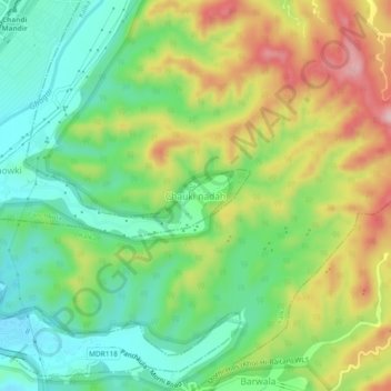
Name: Chauki nadah topographic map, elevation, terrain.
Location: Chauki nadah, Panchkula, Haryana, 134107, India (30.68804 76.88878 30.72804 76.92878)
Average elevation: 435 m
Minimum elevation: 347 m
Maximum elevation: 570 m
Thank you for supporting this site ❤️
Make a donation
Make a donation
Other topographic maps
Click on a map to view its topography, its elevation and its terrain.