
Thank you for supporting this site ❤️
Make a donation
Make a donation
Graulet topographic map
Click on the map to display elevation.
Thank you for supporting this site ❤️
Make a donation
Make a donation
About this map
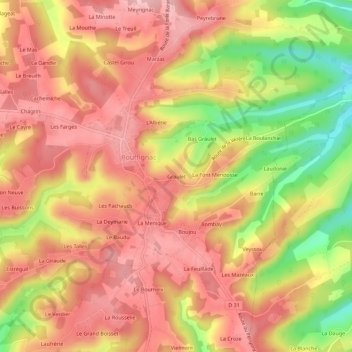
Name: Graulet topographic map, elevation, terrain.
Average elevation: 242 m
Minimum elevation: 135 m
Maximum elevation: 303 m
Thank you for supporting this site ❤️
Make a donation
Make a donation
Other topographic maps
Click on a map to view its topography, its elevation and its terrain.
Saint-Cernin-de-Reillac
France > Nouvelle-Aquitaine > Dordogne > Rouffignac-Saint-Cernin-de-Reilhac
Average elevation: 229 m