
Thank you for supporting this site ❤️
Make a donation
Make a donation
Sorsele topographic map
Click on the map to display elevation.
Thank you for supporting this site ❤️
Make a donation
Make a donation
About this map
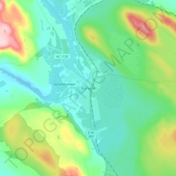
Name: Sorsele topographic map, elevation, terrain.
Location: Sorsele, Sorsele kommun, Västerbottens län, 920 70, Zweden (65.49307 17.49687 65.57307 17.57687)
Average elevation: 385 m
Minimum elevation: 333 m
Maximum elevation: 539 m
Thank you for supporting this site ❤️
Make a donation
Make a donation
Other topographic maps
Click on a map to view its topography, its elevation and its terrain.