
Thank you for supporting this site ❤️
Make a donation
Make a donation
Lac Minogami topographic map
Click on the map to display elevation.
Thank you for supporting this site ❤️
Make a donation
Make a donation
About this map
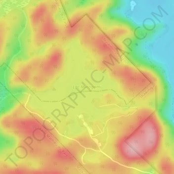
Name: Lac Minogami topographic map, elevation, terrain.
Average elevation: 260 m
Minimum elevation: 170 m
Maximum elevation: 330 m
Thank you for supporting this site ❤️
Make a donation
Make a donation
Other topographic maps
Click on a map to view its topography, its elevation and its terrain.
Dûché de Bicolline
Canada > Québec > Maskinongé (MRC) > Saint-Mathieu-du-Parc
Average elevation: 214 m