
Thank you for supporting this site ❤️
Make a donation
Make a donation
Lindesbergs kommun topographic map
Click on the map to display elevation.
Thank you for supporting this site ❤️
Make a donation
Make a donation
About this map
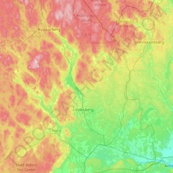
Name: Lindesbergs kommun topographic map, elevation, terrain.
Location: Lindesbergs kommun, Örebro County, Sweden (59.36831 14.90541 59.97613 15.73096)
Average elevation: 151 m
Minimum elevation: 6 m
Maximum elevation: 419 m
Thank you for supporting this site ❤️
Make a donation
Make a donation
Other topographic maps
Click on a map to view its topography, its elevation and its terrain.