
Make a donation
Jones Point topographic map
Click on the map to display elevation.
Make a donation
About this map
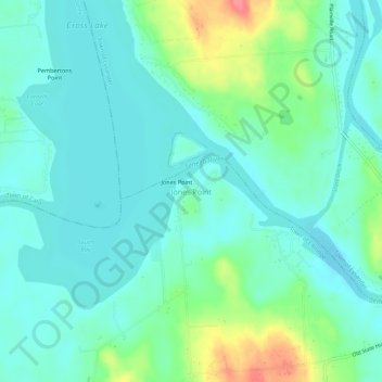
Name: Jones Point topographic map, elevation, terrain.
Average elevation: 125 m
Minimum elevation: 108 m
Maximum elevation: 179 m
Make a donation
Other topographic maps
Click on a map to view its topography, its elevation and its terrain.
Make a donation
Village of Fayetteville
United States > New York > Onondaga County > Town of Manlius
Average elevation: 164 m
Make a donation
Make a donation
Make a donation
Village of Liverpool
United States > New York > Onondaga County > Town of Salina
Average elevation: 117 m
Make a donation
Village of Baldwinsville
United States > New York > Onondaga County > Town of Lysander
Average elevation: 132 m
Make a donation
Village of Baldwinsville
United States > New York > Onondaga County > Town of Lysander
Average elevation: 132 m
Village of Baldwinsville
United States > New York > Onondaga County > Town of Lysander
Average elevation: 132 m
Village of Liverpool
United States > New York > Onondaga County > Town of Salina
Average elevation: 117 m
Make a donation
Make a donation
Village of Baldwinsville
United States > New York > Onondaga County > Town of Lysander
Average elevation: 132 m
Village of Liverpool
United States > New York > Onondaga County > Town of Salina
Average elevation: 117 m
Lyncourt
United States > New York > Onondaga County > Town of Salina > Lyncourt
Average elevation: 136 m
Make a donation
Make a donation
Make a donation
Make a donation
Make a donation