
Ibiza topographic map
Interactive map
Click on the map to display elevation.
About this map
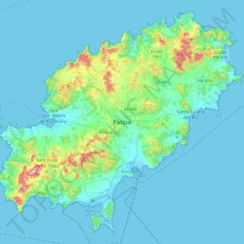
Name: Ibiza topographic map, elevation, terrain.
Location: Ibiza, Balearische Inseln, Spanien (38.83042 1.21327 39.11841 1.62159)
Average elevation: 52 m
Minimum elevation: -4 m
Maximum elevation: 470 m
Die Nordküste, es amunts, die Anhöhen, stehen weitestgehend unter Naturschutz. Das Gebiet reicht von dem Hochplateau bei Santa Agnès de Corona bis zur Nord-Ostspitze der Insel zur Punta Grossa in der Nähe der Cala San Vicente. Diese Region ist dünn besiedelt, es gibt kaum Ortschaften und nur wenige zugängliche Buchten oder Strände und daher fast keinen Tourismus.