
Stockton-on-Tees topographic map
Interactive map
Click on the map to display elevation.
About this map
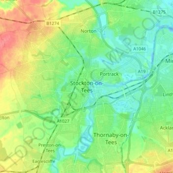
Name: Stockton-on-Tees topographic map, elevation, terrain.
Average elevation: 20 m
Minimum elevation: -13 m
Maximum elevation: 55 m
Other topographic maps
Click on a map to view its topography, its elevation and its terrain.
Stockton-on-Tees
United Kingdom > England > Stockton-on-Tees > Stockton-on-Tees
Stockton-on-Tees, North East England, England, United Kingdom
Average elevation: 17 m
Six Fields Nature Reserve
United Kingdom > England > Stockton-on-Tees > Stockton-on-Tees
Six Fields Nature Reserve, Parkwood Drive, Hartburn Village, Stockton-on-Tees, Tees Valley, England, TS18 5DN, United Kingdom
Average elevation: 18 m