
Thank you for supporting this site ❤️
Make a donation
Make a donation
Durham topographic map
Click on the map to display elevation.
Thank you for supporting this site ❤️
Make a donation
Make a donation
Durham
Durham is located in the east–central part of the Piedmont region at 35°59′19″N 78°54′26″W / 35.98861°N 78.90722°W / 35.98861; -78.90722 (35.99, -78.9). Like much of the region, its topography is generally flat with some rolling hills.
Thank you for supporting this site ❤️
Make a donation
Make a donation
About this map
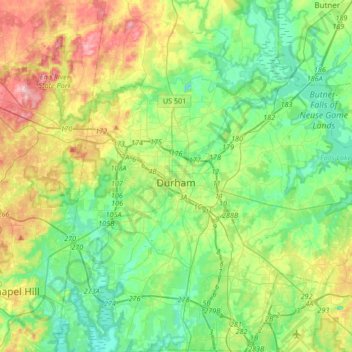
Name: Durham topographic map, elevation, terrain.
Location: Durham, Durham County, North Carolina, United States (35.86635 -79.00750 36.13701 -78.75691)
Average elevation: 117 m
Minimum elevation: 61 m
Maximum elevation: 238 m
Thank you for supporting this site ❤️
Make a donation
Make a donation
Other topographic maps
Click on a map to view its topography, its elevation and its terrain.
Thank you for supporting this site ❤️
Make a donation
Make a donation
Thank you for supporting this site ❤️
Make a donation
Make a donation
Thank you for supporting this site ❤️
Make a donation
Make a donation