
Thank you for supporting this site ❤️
Make a donation
Make a donation
Dong Phu topographic map
Click on the map to display elevation.
Thank you for supporting this site ❤️
Make a donation
Make a donation
About this map
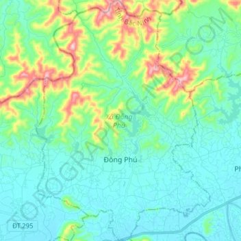
Name: Dong Phu topographic map, elevation, terrain.
Location: Dong Phu, Bắc Ninh Province, Vietnam (21.32640 106.39580 21.44361 106.48674)
Average elevation: 77 m
Minimum elevation: 3 m
Maximum elevation: 348 m
Thank you for supporting this site ❤️
Make a donation
Make a donation
Other topographic maps
Click on a map to view its topography, its elevation and its terrain.