
Thank you for supporting this site ❤️
Make a donation
Make a donation
Lake Michigan Beach topographic map
Click on the map to display elevation.
Thank you for supporting this site ❤️
Make a donation
Make a donation
About this map
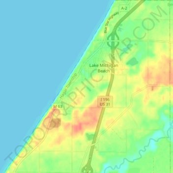
Name: Lake Michigan Beach topographic map, elevation, terrain.
Average elevation: 192 m
Minimum elevation: 175 m
Maximum elevation: 221 m
Thank you for supporting this site ❤️
Make a donation
Make a donation
Other topographic maps
Click on a map to view its topography, its elevation and its terrain.
Grand Mere State Park
United States > Michigan > Berrien County > Lincoln Charter Township
Average elevation: 185 m
Grand Mere State Park
United States > Michigan > Berrien County > Stevensville
Average elevation: 185 m
Thank you for supporting this site ❤️
Make a donation
Make a donation
Grand Mere State Park
United States > Michigan > Berrien County > Stevensville
Average elevation: 185 m
Grand Mere State Park
United States > Michigan > Berrien County > Lincoln Charter Township
Average elevation: 185 m
Thank you for supporting this site ❤️
Make a donation
Make a donation
Thank you for supporting this site ❤️
Make a donation
Make a donation