
Koblenz topographic map
Interactive map
Click on the map to display elevation.
About this map
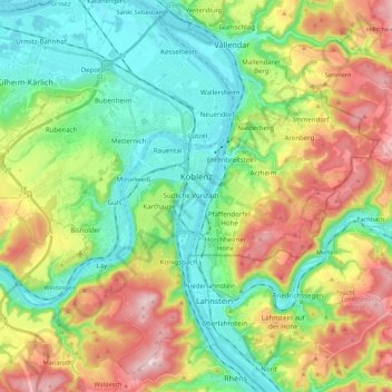
Name: Koblenz topographic map, elevation, terrain.
Location: Koblenz, Rheinland-Pfalz, Deutschland (50.28300 7.47825 50.40969 7.69644)
Average elevation: 181 m
Minimum elevation: 57 m
Maximum elevation: 398 m
Koblenz liegt laut Angabe des Bundesamtes für Kartographie und Geodäsie auf 73 m ü. NHN. Das Deutsche Eck liegt bei 64,7 m Höhe. Die höchste vollständig im Stadtgebiet gelegene Erhebung ist mit 382 m der Kühkopf im Stadtwald. Die höchste Stelle des Stadtgebietes mit 385 m befindet sich auf der Grenze zur Stadt Rhens am Nordhang des Maulbeerkopfes, dessen 395 m hoher Gipfel sich auf Rhenser Stadtgebiet befindet.
Other topographic maps
Click on a map to view its topography, its elevation and its terrain.
Niederberg
Deutschland > Rheinland-Pfalz > Koblenz
Niederberg, Koblenz, Rheinland-Pfalz, Deutschland
Average elevation: 147 m