
Thank you for supporting this site ❤️
Make a donation
Make a donation
La Hutte topographic map
Click on the map to display elevation.
Thank you for supporting this site ❤️
Make a donation
Make a donation
About this map
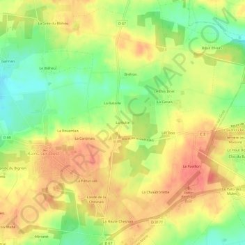
Name: La Hutte topographic map, elevation, terrain.
Average elevation: 47 m
Minimum elevation: 15 m
Maximum elevation: 70 m
Thank you for supporting this site ❤️
Make a donation
Make a donation
Other topographic maps
Click on a map to view its topography, its elevation and its terrain.
35600
France > Bretagne > Ille-et-Vilaine > Bains-sur-Oust > La Haute Chesnais
Average elevation: 33 m