
Make a donation
Alburquerque topographic map
Click on the map to display elevation.
Make a donation
Alburquerque
The central part of municipality, from the east extending toward northwest is characterized by rolling to moderately steep terrain (18-30% slope), with ground elevation ranging from 80 to 131 m (262 to 430 ft) amsl. The area in northeastern and southwestern part is characterized by steep terrain (30–50% slope), with ground elevation up to 153 m (502 ft) amsl. The southeastern part is characterized with undulating to rolling terrain (8–18% slope) with ground elevation up to 60 m (200 ft) amsl. The area along the coast is characterized by level to nearly level terrain (0-3% slope), with ground elevation ranging from zero near the coast to 10 m (33 ft) amsl inland.
Make a donation
About this map
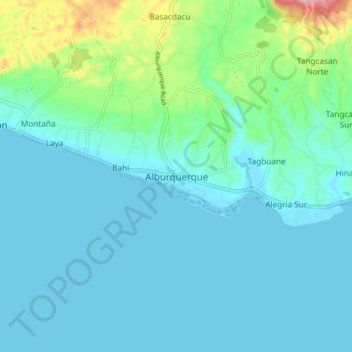
Name: Alburquerque topographic map, elevation, terrain.
Location: Alburquerque, Bohol, Central Visayas, 6302, Philippines (9.57035 123.91690 9.65035 123.99690)
Average elevation: 36 m
Minimum elevation: -1 m
Maximum elevation: 225 m
Make a donation
Other topographic maps
Click on a map to view its topography, its elevation and its terrain.
Make a donation
Make a donation
Make a donation
Make a donation
Make a donation
Make a donation
Make a donation
Make a donation
Make a donation
Make a donation
Make a donation
Make a donation
Make a donation