
Koratty topographic map
Interactive map
Click on the map to display elevation.
About this map
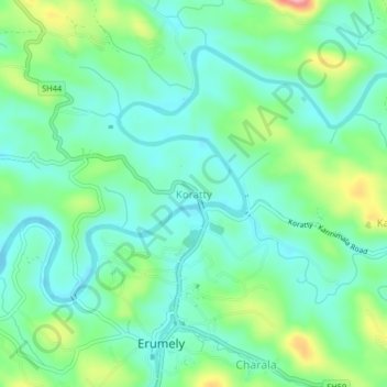
Name: Koratty topographic map, elevation, terrain.
Location: Koratty, Kanjirappally, Kottayam, Kerala, 686509, India (9.47679 76.82832 9.51679 76.86832)
Average elevation: 75 m
Minimum elevation: 35 m
Maximum elevation: 180 m
Other topographic maps
Click on a map to view its topography, its elevation and its terrain.
Ponkunnam
India > Kerala > Kanjirappally
Ponkunnam, Kanjirappally, Kottayam District, Kerala, 686519, India
Average elevation: 83 m
Elivalikkara
India > Kerala > Kanjirappally > Mukkoottuthara
Elivalikkara, Mukkoottuthara, Kanjirappally, Kottayam District, Kerala, India
Average elevation: 167 m
Kunnumbhagam
India > Kerala > Kanjirappally > Kanjirappalli
Kunnumbhagam, Kanjirappalli, Kanjirappally, Kottayam District, Kerala, 686507, India
Average elevation: 74 m
Podimattom
India > Kerala > Kanjirappally
Podimattom, Kanjirappally, Kottayam District, Kerala, 686512, India
Average elevation: 83 m
Mukkada
India > Kerala > Kanjirappally
Mukkada, Kanjirappally, Kottayam, Kerala, 686511, India
Average elevation: 108 m
Nadukani
India > Kerala > Kanjirappally > Mundakkayam
Nadukani, Mundakkayam, Kanjirappally, Kottayam, Kerala, 686513, India
Average elevation: 159 m
Parathodu (28Mile)
India > Kerala > Kanjirappally
Parathodu (28Mile), Kanjirappally, Kottayam, Kerala, 686512, India
Average elevation: 104 m
Chenappady
India > Kerala > Kanjirappally > Chenappady
Chenappady, Kanjirappally, Kottayam, Kerala, 686520, India
Average elevation: 64 m