
Thank you for supporting this site ❤️
Make a donation
Make a donation
Madana topographic map
Click on the map to display elevation.
Thank you for supporting this site ❤️
Make a donation
Make a donation
About this map
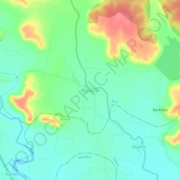
Name: Madana topographic map, elevation, terrain.
Location: Madana, Arvi, Wardha, Maharashtra, India (20.87737 78.52242 20.91737 78.56242)
Average elevation: 295 m
Minimum elevation: 272 m
Maximum elevation: 341 m
Thank you for supporting this site ❤️
Make a donation
Make a donation
Other topographic maps
Click on a map to view its topography, its elevation and its terrain.
Arvi
India > Maharashtra > Arvi
Arvi is located at 20°35′N 79°08′E / 20.59°N 79.14°E / 20.59; 79.14. It has an average elevation of 328 metres (1075 feet). Arvi is an important centre for the cotton and soybean trade. The closest airport from Arvi is Nagpur Airport situated at 100 kilometres and the closest Railway Station…
Average elevation: 302 m