
Make a donation
McGrady topographic map
Click on the map to display elevation.
Make a donation
About this map
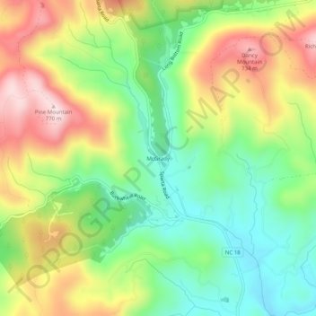
Name: McGrady topographic map, elevation, terrain.
Location: McGrady, Wilkes County, North Carolina, 28649, United States (36.31269 -81.24668 36.35269 -81.20668)
Average elevation: 559 m
Minimum elevation: 406 m
Maximum elevation: 764 m
Make a donation
Other topographic maps
Click on a map to view its topography, its elevation and its terrain.
Make a donation
Doughton Park
United States > North Carolina > Wilkes County
Doughton Park (Doughton Recreational Area) is the largest recreation area the National Park Service manages on the Blue Ridge Parkway. It is located between mile markers 238.5 - 244.7 on the border between Wilkes and Alleghany Counties in North Carolina. Doughton Park consists of highland meadows with numerous…
Average elevation: 855 m
Stone Mountain State Park
United States > North Carolina > Wilkes County
The centerpiece of the park is Stone Mountain, a dome of exposed granite (specifically a quartz diorite to granodiorite) of Devonian age, which has intruded into the gneiss of the Precambrian Alligator Back Formation. It rises sharply over 600 feet (183 m) above the surrounding terrain. The mountain, which has…
Average elevation: 641 m
Make a donation
Moravian Falls
United States > North Carolina > Wilkes County > Moravian Falls
Average elevation: 362 m
Make a donation