
Thank you for supporting this site ❤️
Make a donation
Make a donation
Silvertop topographic map
Click on the map to display elevation.
Thank you for supporting this site ❤️
Make a donation
Make a donation
About this map
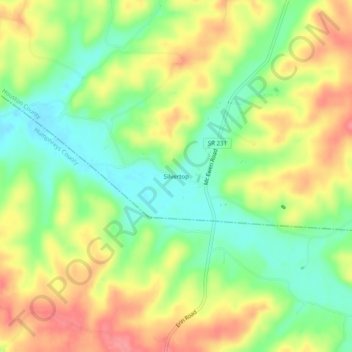
Name: Silvertop topographic map, elevation, terrain.
Average elevation: 193 m
Minimum elevation: 153 m
Maximum elevation: 238 m
Thank you for supporting this site ❤️
Make a donation
Make a donation
Other topographic maps
Click on a map to view its topography, its elevation and its terrain.
Tennessee Ridge
United States > Tennessee > Houston County
Tennessee Ridge is located at 36°19′15″N 87°45′47″W / 36.32083°N 87.76306°W / 36.32083; -87.76306 (36.320797, -87.763012), at an elevation of 742 feet above sea level.
Average elevation: 204 m
Erin
United States > Tennessee > Houston County
Erin is located at 36°19′1″N 87°41′53″W / 36.31694°N 87.69806°W / 36.31694; -87.69806 (36.316998, -87.697946). The elevation is 480 feet above sea level.
Average elevation: 168 m