
Make a donation
Phillipsport topographic map
Click on the map to display elevation.
Make a donation
About this map
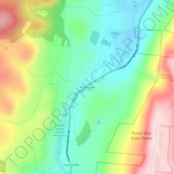
Name: Phillipsport topographic map, elevation, terrain.
Average elevation: 264 m
Minimum elevation: 119 m
Maximum elevation: 488 m
Make a donation
Other topographic maps
Click on a map to view its topography, its elevation and its terrain.
Make a donation
Livingston Manor
United States > New York > Sullivan County > Livingston Manor
Average elevation: 515 m
Tusten Mountain Lake
United States > New York > Sullivan County > Town of Tusten
Average elevation: 346 m
Village of Wurtsboro
United States > New York > Sullivan County
Wurtsboro is in the Eastern Time Zone. Its elevation is 577 feet.
Average elevation: 204 m
Make a donation
Make a donation
Mountain Dale
United States > New York > Sullivan County > Town of Fallsburg
Mountaindale is a hamlet (and census-designated place) in the town of Fallsburg in Sullivan County, New York, United States, situated at an altitude of 1,010 feet (310 m).
Average elevation: 363 m
Make a donation
Make a donation
Livingston Manor
United States > New York > Sullivan County > Livingston Manor
Average elevation: 512 m
Make a donation
Make a donation
Grahamsville
United States > New York > Sullivan County > Town of Neversink
Grahamsville is located at latitude 41.848 and longitude -74.548. The elevation is 968 feet. Grahamsville is in the Eastern Time Zone.
Average elevation: 397 m
Livingston Manor
United States > New York > Sullivan County > Livingston Manor
Average elevation: 512 m
Make a donation
Woodbourne
United States > New York > Sullivan County > Town of Fallsburg > Woodbourne
Average elevation: 394 m
Make a donation
Grahamsville
United States > New York > Sullivan County > Town of Neversink
Grahamsville is located at latitude 41.848 and longitude -74.548. The elevation is 968 feet. Grahamsville is in the Eastern Time Zone.
Average elevation: 397 m
Make a donation
Town of Lumberland
United States > New York > Sullivan County
Lumberland is located within the Upper Delaware Scenic and Recreational River. Elevations range from approximately 600 feet near the Delaware River to over 1,300 feet above sea level on the bluffs overlooking the Delaware, and where the Catskill Mountains begin to rise in the northern reaches of the town. The…
Average elevation: 360 m
Make a donation