
Make a donation
Drenajic topographic map
Click on the map to display elevation.
Make a donation
About this map
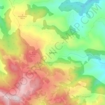
Name: Drenajic topographic map, elevation, terrain.
Average elevation: 709 m
Minimum elevation: 429 m
Maximum elevation: 1,006 m
Make a donation
Other topographic maps
Click on a map to view its topography, its elevation and its terrain.
Jajcic
Serbia > Central Serbia > Kolubara Administrative District > Ljig Municipality
Average elevation: 154 m
Лајковац (село)
Serbia > Central Serbia > Kolubara Administrative District > Lajkovac Municipality
Average elevation: 128 m
Dici
Serbia > Central Serbia > Kolubara Administrative District > Ljig Municipality
Average elevation: 273 m
Gornji Music
Serbia > Central Serbia > Kolubara Administrative District > Mionica Municipality
Average elevation: 199 m
Make a donation
Belanovica
Serbia > Central Serbia > Kolubara Administrative District > Ljig Municipality
Average elevation: 231 m
Sutci
Serbia > Central Serbia > Kolubara Administrative District > Ljig Municipality
Average elevation: 278 m
Liplje
Serbia > Central Serbia > Kolubara Administrative District > Ljig Municipality
Average elevation: 191 m
Divcibare
Serbia > Central Serbia > Kolubara Administrative District
Divčibare (Serbian Cyrillic: Дивчибаре; pronounced [dǐʋtʃibarɛ]) is a town and mountain resort situated on the mountain Maljen (1104 m) in western Serbia, south-east of Valjevo, at the altitude of 980 metres above sea level. The permanent population of the town is 141 people (2011 census),…
Average elevation: 842 m
Make a donation
Divcibare
Serbia > Central Serbia > Kolubara Administrative District
Divčibare (Serbian Cyrillic: Дивчибаре; pronounced [dǐʋtʃibarɛ]) is a town and mountain resort situated on the mountain Maljen (1104 m) in western Serbia, south-east of Valjevo, at the altitude of 980 metres above sea level. The permanent population of the town is 141 people (2011 census),…
Average elevation: 842 m
Gornji Lajkovac
Serbia > Central Serbia > Kolubara Administrative District > Mionica Municipality
Average elevation: 555 m
Osecina Municipality
Serbia > Central Serbia > Kolubara Administrative District
Average elevation: 401 m
Make a donation
Valjevo
Serbia > Central Serbia > Kolubara Administrative District
Valjevo occupies an area of 905 square kilometers; its altitude is 185 meters. The city is situated along the river Kolubara, a tributary of the Sava river.
Average elevation: 258 m
Vrhovine
Serbia > Central Serbia > Kolubara Administrative District > Ub Municipality
Average elevation: 198 m
Make a donation
Колубара
Serbia > Central Serbia > Kolubara Administrative District > Lajkovac Municipality
Average elevation: 128 m