
Kananaskis Improvement District topographic map
Interactive map
Click on the map to display elevation.
About this map
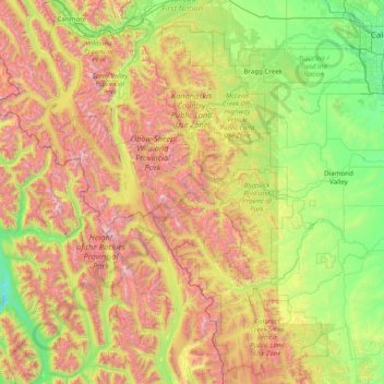
Name: Kananaskis Improvement District topographic map, elevation, terrain.
Location: Kananaskis Improvement District, Alberta, Canadá (50.13416 -115.46930 51.13288 -114.32241)
Average elevation: 1,740 m
Minimum elevation: 900 m
Maximum elevation: 3,387 m
Other topographic maps
Click on a map to view its topography, its elevation and its terrain.
Drumheller (town)
Drumheller (town), Alberta, T0J 2V0, Canadá
Average elevation: 855 m
Río Athabasca
Río Athabasca, Municipal District of Lesser Slave River, Alberta, T9S 1H4, Canadá
Average elevation: 696 m