
Mont Turia topographic map
Interactive map
Click on the map to display elevation.
About this map
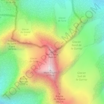
Name: Mont Turia topographic map, elevation, terrain.
Average elevation: 3,048 m
Minimum elevation: 2,518 m
Maximum elevation: 3,774 m
Other topographic maps
Click on a map to view its topography, its elevation and its terrain.
Mont Pourri
France > Auvergne-Rhône-Alpes > Villaroger
Mont Pourri, Villaroger, Albertville, Savoie, Auvergne-Rhône-Alpes, France métropolitaine, 73640, France
Average elevation: 3,086 m