
Thank you for supporting this site ❤️
Make a donation
Make a donation
Fronteira topographic map
Click on the map to display elevation.
Thank you for supporting this site ❤️
Make a donation
Make a donation
About this map
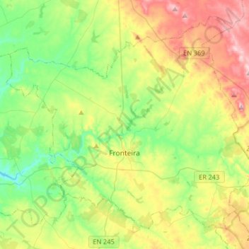
Name: Fronteira topographic map, elevation, terrain.
Location: Fronteira, Portalegre, Portugal (38.99067 -7.77249 39.16703 -7.51205)
Average elevation: 227 m
Minimum elevation: 128 m
Maximum elevation: 396 m
Thank you for supporting this site ❤️
Make a donation
Make a donation
Other topographic maps
Click on a map to view its topography, its elevation and its terrain.