
Cư M'gar District topographic map
Interactive map
Click on the map to display elevation.
About this map
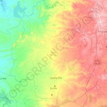
Name: Cư M'gar District topographic map, elevation, terrain.
Location: Cư M'gar District, Đắk Lắk Province, Vietnam (12.71557 107.91686 13.07603 108.22667)
Average elevation: 470 m
Minimum elevation: 191 m
Maximum elevation: 856 m
Other topographic maps
Click on a map to view its topography, its elevation and its terrain.
Buôn Ma Thuột
Buôn Ma Thuột, Đắk Lắk Province, Vietnam
Average elevation: 442 m
Ea H'leo District
Ea H'leo District, Đăk Lăk Province, Vietnam
Average elevation: 481 m
Buôn Hồ District
Buôn Hồ District, Đắk Lắk province, Vietnam
Average elevation: 620 m
Buôn Ma Thuột
Vietnam > Đắk Lắk province > Buon Ma Thuot > Buôn Ma Thuột
Buôn Ma Thuột, Buon Ma Thuot, Đắk Lắk province, 63000, Vietnam
Average elevation: 437 m