
Thank you for supporting this site ❤️
Make a donation
Make a donation
Kreuth topographic map
Click on the map to display elevation.
Thank you for supporting this site ❤️
Make a donation
Make a donation
About this map
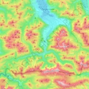
Name: Kreuth topographic map, elevation, terrain.
Location: Kreuth, Landkreis Miesbach, Beieren, 83708, Duitsland (47.58121 11.59798 47.70095 11.85496)
Average elevation: 1,137 m
Minimum elevation: 722 m
Maximum elevation: 1,823 m
Thank you for supporting this site ❤️
Make a donation
Make a donation
Other topographic maps
Click on a map to view its topography, its elevation and its terrain.