
Salvanhac topographic map
Interactive map
Click on the map to display elevation.
About this map
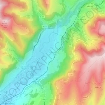
Name: Salvanhac topographic map, elevation, terrain.
Average elevation: 873 m
Minimum elevation: 653 m
Maximum elevation: 1,161 m
Other topographic maps
Click on a map to view its topography, its elevation and its terrain.
Olmet
France > Auvergne-Rhône-Alpes > Cantal > Vic-sur-Cère > Olmet
Olmet, Vic-sur-Cère, Aurillac, Cantal, Auvergne-Rhône-Alpes, France métropolitaine, 15800, France
Average elevation: 816 m
Aliquier
France > Auvergne-Rhône-Alpes > Cantal > Vic-sur-Cère
Aliquier, Vic-sur-Cère, Aurillac, Cantal, Auvergne-Rhône-Alpes, France métropolitaine, 15800, France
Average elevation: 916 m