
Thank you for supporting this site ❤️
Make a donation
Make a donation
Lashmeet topographic map
Click on the map to display elevation.
Thank you for supporting this site ❤️
Make a donation
Make a donation
About this map
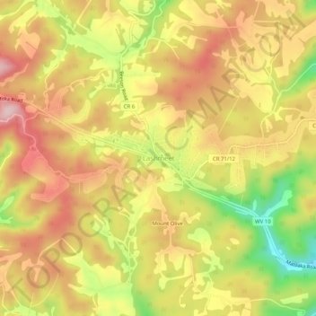
Name: Lashmeet topographic map, elevation, terrain.
Location: Lashmeet, Mercer County, West Virginia, 24747, United States (37.40030 -81.21597 37.44030 -81.17597)
Average elevation: 792 m
Minimum elevation: 647 m
Maximum elevation: 896 m
Thank you for supporting this site ❤️
Make a donation
Make a donation
Other topographic maps
Click on a map to view its topography, its elevation and its terrain.
Pinnacle Rock State Park
United States > West Virginia > Mercer County > Nemours
Average elevation: 772 m