
Thank you for supporting this site ❤️
Make a donation
Make a donation
Jorkanden topographic map
Click on the map to display elevation.
Thank you for supporting this site ❤️
Make a donation
Make a donation
About this map
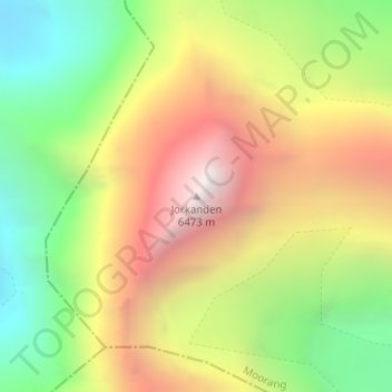
Name: Jorkanden topographic map, elevation, terrain.
Location: Jorkanden, Moorang, Kinnaur, Himachal Pradesh, India (31.49175 78.37306 31.49185 78.37316)
Average elevation: 5,506 m
Minimum elevation: 4,636 m
Maximum elevation: 6,470 m
Thank you for supporting this site ❤️
Make a donation
Make a donation
Other topographic maps
Click on a map to view its topography, its elevation and its terrain.