
Thank you for supporting this site ❤️
Make a donation
Make a donation
Lewistown topographic map
Click on the map to display elevation.
Thank you for supporting this site ❤️
Make a donation
Make a donation
About this map
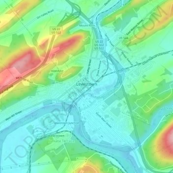
Name: Lewistown topographic map, elevation, terrain.
Location: Lewistown, Mifflin County, Pennsylvania, United States (40.58369 -77.60409 40.61327 -77.55177)
Average elevation: 181 m
Minimum elevation: 135 m
Maximum elevation: 298 m
Thank you for supporting this site ❤️
Make a donation
Make a donation
Other topographic maps
Click on a map to view its topography, its elevation and its terrain.