
Make a donation
Cagua topographic map
Click on the map to display elevation.
Make a donation
About this map
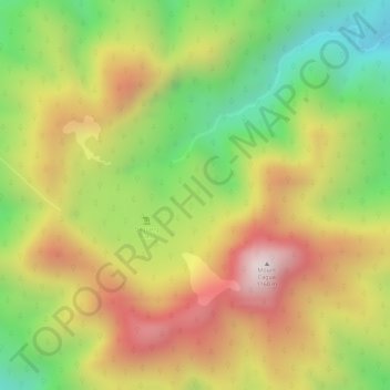
Name: Cagua topographic map, elevation, terrain.
Location: Cagua, Cagayan, Cagayan Valley, Philippines (18.21178 122.10517 18.23003 122.12552)
Average elevation: 809 m
Minimum elevation: 454 m
Maximum elevation: 1,136 m
Make a donation
Other topographic maps
Click on a map to view its topography, its elevation and its terrain.
Make a donation
Enrile
Enrile is bounded by hills and mountains on both North and West. Area with low elevation is about 20 meters above sea level at the Eastern part which lies close to the river boundaries. The highest elevation is found Northwest which is approximately 800 meters above sea level.
Average elevation: 45 m
Make a donation
Make a donation
Rizal
The Sinicking National Park has the height of 801 metres (2,628 ft) and the highest elevation between the town's Poblacion and barangay Gaddangao is 1,004 metres (3,294 ft). The entrance to the town is very similar to the Kennon Road of Baguio.
Average elevation: 154 m
Make a donation
Make a donation
Make a donation
Make a donation
Make a donation
Make a donation
Make a donation
Make a donation
Make a donation
Gonzaga
It has a total land area of 56,743 hectares (140,220 acres), the majority of which remains undeveloped. It has large stretches of virgin forests, especially throughout the mountainous areas of the Sierra Madre mountain range. The highest elevation in the municipality is 1,130 metres (3,710 ft) above sea level,…
Average elevation: 38 m
Make a donation
Make a donation
Make a donation
Make a donation
Make a donation
Make a donation
Make a donation
Make a donation
Make a donation
Mount Pangasun
Philippines > Cagayan > Calayan
Babuyan Claro is a stratovolcano with an elevation of 843 meters (2,766 ft) and a base diameter of about 8 kilometers (5.0 mi) located in the center of Babuyan Island (also referred to as Babuyan Claro Island). It has four morphologically-fresh volcanic edifices: Mt. Cayonan in the south, Mt. Naydi and Mt.…
Average elevation: 688 m
Make a donation
Make a donation
Make a donation
Make a donation