
Make a donation
Skellingthorpe topographic map
Click on the map to display elevation.
Make a donation
About this map
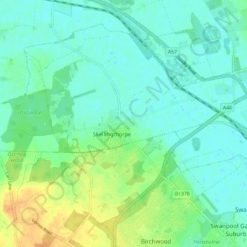
Name: Skellingthorpe topographic map, elevation, terrain.
Average elevation: 11 m
Minimum elevation: 2 m
Maximum elevation: 31 m
Make a donation
Other topographic maps
Click on a map to view its topography, its elevation and its terrain.
Long Holt Wood
United Kingdom > England > Lincolnshire > North Kesteven > Nocton
Average elevation: 20 m
Make a donation
Make a donation
Three Kings Deer
United Kingdom > England > Lincolnshire > North Kesteven > Threekingham
Average elevation: 24 m
Make a donation
Quarrington
United Kingdom > England > Lincolnshire > North Kesteven
According to the Köppen classification, the British Isles experience a maritime climate characterised by relatively cool summers and mild winters. Lincolnshire's position on the east of the Isles allows for a sunnier and warmer climate relative to the national average, and it is one of the driest counties in…
Average elevation: 21 m
Make a donation
Make a donation
Make a donation
Make a donation
Make a donation
Doddington
United Kingdom > England > Lincolnshire > North Kesteven > Doddington
Average elevation: 19 m
Make a donation
Threekingham
United Kingdom > England > Lincolnshire > North Kesteven > Threekingham
Average elevation: 30 m
Make a donation
Helpringham
United Kingdom > England > Lincolnshire > North Kesteven > Helpringham
Average elevation: 8 m
Make a donation