
Thank you for supporting this site ❤️
Make a donation
Make a donation
La Yaule topographic map
Click on the map to display elevation.
Thank you for supporting this site ❤️
Make a donation
Make a donation
About this map
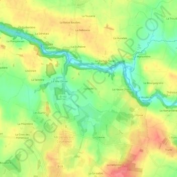
Name: La Yaule topographic map, elevation, terrain.
Average elevation: 77 m
Minimum elevation: 41 m
Maximum elevation: 112 m
Thank you for supporting this site ❤️
Make a donation
Make a donation
Other topographic maps
Click on a map to view its topography, its elevation and its terrain.
Château de la Ville Olivier
France > Bretagne > Ille-et-Vilaine > Mézières-sur-Couesnon > La Ville Olivier
Average elevation: 74 m