
Make a donation
Somogy topographic map
Click on the map to display elevation.
Make a donation
About this map
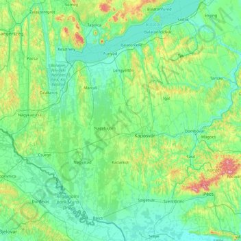
Name: Somogy topographic map, elevation, terrain.
Location: Somogy, Southern Transdanubia, Transdanubia, Hungary (45.84824 16.87527 46.99731 18.21329)
Average elevation: 163 m
Minimum elevation: 91 m
Maximum elevation: 670 m
Make a donation
Other topographic maps
Click on a map to view its topography, its elevation and its terrain.
Make a donation
Make a donation
Vértes
The area of the Vértes occupies 314 km2 (121 sq mi). It is about 30 km long and 10–15 km wide. The average altitude is above sea level is 350 meters; its highest points are 487 m (Nagy-Csákány), 480 m (Körtvélyes) and 479 m (Csóka-hegy). Geologically the Vértes constitute a fairly uniform structure.…
Average elevation: 245 m
Make a donation
Zemplén Mountains
Zemplén Mountains (Hungarian: [ˈzɛmpleːn]) or Tokaj Mountains (Hungarian: [ˈtokɒj]; Hungarian: Zempléni-hegység or Tokaji-hegység) is a mountain range in Hungary. The Zemplén Mountains form part of the Tokaj-Eperjes mountain chain in Hungary, known for their ecological richness and historical…
Average elevation: 206 m
Make a donation
Make a donation
Make a donation
Make a donation
Make a donation
Make a donation
Pannonian Basin
Pannonian basin vs Carpathian basin: On the territory of present-day Hungary the ancient Roman Pannonia province was located only on Transdanubian territories, however the Great Hungarian Plain was not part of Pannonia province. This comprises less than 29% of modern Hungary, therefore Hungarian geographers…
Average elevation: 99 m
Make a donation
Make a donation
Make a donation
Pécs
Pécs is bordered by plains to the south (elevation 120–130 m), while the Mecsek mountains rise up to elevations of 400–600 meters behind the city. Jakab-hill, located in the western Mecsek, is 592 m (1942 ft) tall, Tubes, straight above Pécs, is 612 m (2008 ft) tall, and Misina is 535 m (1755 ft) tall.…
Average elevation: 210 m
Make a donation
Make a donation
Make a donation
Make a donation
Make a donation
Make a donation
Make a donation
Szentistvánbaksa
Hungary > Borsod-Abaúj-Zemplén > Szentistvánbaksa > Szentistvánbaksa
Average elevation: 163 m
Make a donation
Make a donation
Make a donation
Make a donation