
Make a donation
East Harling topographic map
Click on the map to display elevation.
Make a donation
About this map
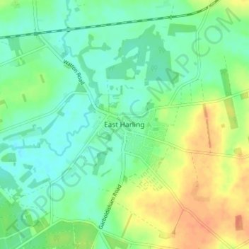
Name: East Harling topographic map, elevation, terrain.
Average elevation: 29 m
Minimum elevation: 14 m
Maximum elevation: 54 m
Make a donation
Other topographic maps
Click on a map to view its topography, its elevation and its terrain.
South Lopham
United Kingdom > England > Norfolk > Breckland District > South Lopham
Average elevation: 36 m
Make a donation
Brettenham Heath - Open Access Land
United Kingdom > England > Norfolk > Breckland District > Brettenham
Average elevation: 40 m
Make a donation
Weasenham All Saints
United Kingdom > England > Norfolk > Breckland District > Weasenham
Average elevation: 71 m
Make a donation
Make a donation
Make a donation
North Tuddenham
United Kingdom > England > Norfolk > Breckland District > North Tuddenham
Average elevation: 41 m
Make a donation
Tittleshall
United Kingdom > England > Norfolk > Breckland District > Tittleshall
Average elevation: 69 m
Make a donation
Make a donation
Whissonsett
United Kingdom > England > Norfolk > Breckland District > Whissonsett
Average elevation: 67 m
Make a donation
Sporle with Palgrave
United Kingdom > England > Norfolk > Breckland District > Sporle
Average elevation: 68 m
Make a donation
Make a donation
Make a donation
Little Dunham
United Kingdom > England > Norfolk > Breckland District > Little Dunham
Average elevation: 79 m
Make a donation
Great Ellingham
United Kingdom > England > Norfolk > Breckland District > Great Ellingham
Average elevation: 43 m
Make a donation
Make a donation
Snetterton
United Kingdom > England > Norfolk > Breckland District > Snetterton
Average elevation: 34 m
Make a donation
Make a donation
Make a donation
Make a donation
Make a donation