
Thank you for supporting this site ❤️
Make a donation
Make a donation
Hummock topographic map
Click on the map to display elevation.
Thank you for supporting this site ❤️
Make a donation
Make a donation
About this map
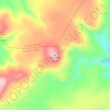
Name: Hummock topographic map, elevation, terrain.
Location: Hummock, Dunedin City, New Zealand (-45.55618 170.38747 -45.55608 170.38757)
Average elevation: 621 m
Minimum elevation: 491 m
Maximum elevation: 734 m
Thank you for supporting this site ❤️
Make a donation
Make a donation
Other topographic maps
Click on a map to view its topography, its elevation and its terrain.