
Thank you for supporting this site ❤️
Make a donation
Make a donation
Meenangadi topographic map
Click on the map to display elevation.
Thank you for supporting this site ❤️
Make a donation
Make a donation
About this map
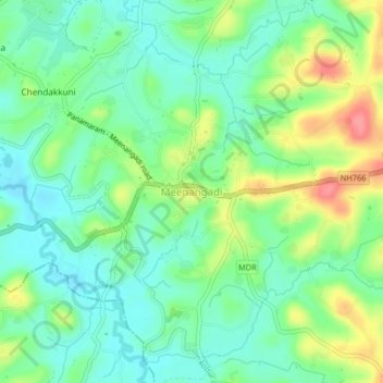
Name: Meenangadi topographic map, elevation, terrain.
Location: Meenangadi, Sulthanbathery, Wayanad, Kerala, 673591, India (11.63947 76.14684 11.67947 76.18684)
Average elevation: 760 m
Minimum elevation: 731 m
Maximum elevation: 815 m
Thank you for supporting this site ❤️
Make a donation
Make a donation
Other topographic maps
Click on a map to view its topography, its elevation and its terrain.
Thank you for supporting this site ❤️
Make a donation
Make a donation
Thank you for supporting this site ❤️
Make a donation
Make a donation