
Make a donation
Jenin topographic map
Click on the map to display elevation.
Make a donation
About this map
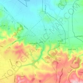
Name: Jenin topographic map, elevation, terrain.
Location: Jenin, Area A, West Bank, 180, Palestinian Territories (32.42188 35.25757 32.50188 35.33757)
Average elevation: 194 m
Minimum elevation: 84 m
Maximum elevation: 391 m
Make a donation
Other topographic maps
Click on a map to view its topography, its elevation and its terrain.
Bethlehem
Palestinian Territories > Area A
Bethlehem is located at an elevation of about 775 meters (2,543 ft) above sea level, 30 meters (98 ft) higher than nearby Jerusalem. Bethlehem is situated on the Judean Mountains.
Average elevation: 705 m
Nablus
Palestinian Territories > Area A
Insofar as the hilly topography of the site would allow, the city was built on a Roman grid plan and settled with veterans who fought in the victorious legions and other foreign colonists. In the 2nd century CE, Emperor Hadrian built a grand theater in Neapolis that could seat up to 7,000 people. Coins found…
Average elevation: 645 m
Make a donation
Ramallah
Palestinian Territories > Area A
Ramallah (UK: /rəˈmælə/ rə-MAL-ə, US: /rəˈmɑːlə/ rə-MAH-lə; Arabic: رام الله, romanized: Rām Allāh; IPA: [raːm alˤ.lˤaːh] ; lit. 'God's Height') is a city in the central West Bank, Palestine. It serves as the administrative capital of Palestine, as well as capital of the Ramallah…
Average elevation: 769 m
Bethlehem
Palestinian Territories > Area A
Bethlehem is located at an elevation of about 775 meters (2,543 ft) above sea level, 30 meters (98 ft) higher than nearby Jerusalem. Bethlehem is situated on the Judean Mountains.
Average elevation: 705 m
Nablus
Palestinian Territories > Area A
Insofar as the hilly topography of the site would allow, the city was built on a Roman grid plan and settled with veterans who fought in the victorious legions and other foreign colonists. In the 2nd century CE, Emperor Hadrian built a grand theater in Neapolis that could seat up to 7,000 people. Coins found…
Average elevation: 645 m
Make a donation
Ramallah
Palestinian Territories > Area A
Ramallah (UK: /rəˈmælə/ rə-MAL-ə, US: /rəˈmɑːlə/ rə-MAH-lə; Arabic: رام الله, romanized: Rām Allāh; IPA: [raːm alˤ.lˤaːh] ; lit. 'God's Height') is a city in the central West Bank, Palestine. It serves as the administrative capital of Palestine, as well as capital of the Ramallah…
Average elevation: 769 m