
Make a donation
Wulauan topographic map
Click on the map to display elevation.
Make a donation
About this map
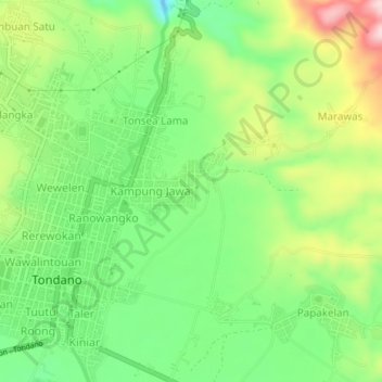
Name: Wulauan topographic map, elevation, terrain.
Location: Wulauan, Minahasa, North Sulawesi, Sulawesi, 95614, Indonesia (1.29045 124.90500 1.33045 124.94500)
Average elevation: 710 m
Minimum elevation: 601 m
Maximum elevation: 877 m
Make a donation
Other topographic maps
Click on a map to view its topography, its elevation and its terrain.
Make a donation
Tomohon
Tomohon has a cooler temperature than Manado (Tomohon's neighbor city) which is at a lower land nearby the sea. Tomohon is situated at an altitude of about 700–1,000 metres (2,300–3,300 ft) above sea level (asl), Temperatures in Tomohon in the daytime are between 17–30 °C (63–86 °F) and 16–24 °C…
Average elevation: 715 m
Make a donation
Kepulauan Sangihe
Topography of the islands mostly consists of hills and steep topography for bigger islands such as Sangihe and Siau. Around 55.4% of land area in the regency has slope above 40%. Soil composition consist of alluvium, which mostly used for residential areas. Elevation varies from 0 to 1,800 metres above sea…
Average elevation: 2 m
Make a donation
Make a donation
Kepulauan Sangihe
Topography of the islands mostly consists of hills and steep topography for bigger islands such as Sangihe and Siau. Around 55.4% of land area in the regency has slope above 40%. Soil composition consist of alluvium, which mostly used for residential areas. Elevation varies from 0 to 1,800 metres above sea…
Average elevation: 2 m
Make a donation