
La Plage topographic map
Interactive map
Click on the map to display elevation.
About this map
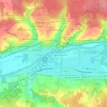
Name: La Plage topographic map, elevation, terrain.
Average elevation: 93 m
Minimum elevation: 53 m
Maximum elevation: 138 m
Other topographic maps
Click on a map to view its topography, its elevation and its terrain.
Aiguevives
France > Centre-Val de Loire > Loir-et-Cher > Faverolles-sur-Cher
Aiguevives, Faverolles-sur-Cher, Romorantin-Lanthenay, Loir-et-Cher, Centre-Val de Loire, France métropolitaine, 41400, France
Average elevation: 139 m
Le Bout du Pont
France > Centre-Val de Loire > Loir-et-Cher > Faverolles-sur-Cher
Le Bout du Pont, Faverolles-sur-Cher, Romorantin-Lanthenay, Loir-et-Cher, Centre-Val de Loire, France métropolitaine, 41400, France
Average elevation: 92 m