
Thank you for supporting this site ❤️
Make a donation
Make a donation
Antofagasta Region topographic map
Click on the map to display elevation.
Thank you for supporting this site ❤️
Make a donation
Make a donation
About this map
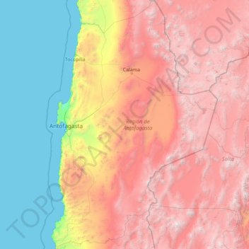
Name: Antofagasta Region topographic map, elevation, terrain.
Location: Antofagasta Region, Chile (-26.06110 -70.73714 -20.93439 -66.99052)
Average elevation: 2,361 m
Minimum elevation: 0 m
Maximum elevation: 6,437 m
Thank you for supporting this site ❤️
Make a donation
Make a donation
Other topographic maps
Click on a map to view its topography, its elevation and its terrain.
Tupungato
Chile > Santiago Metropolitan Region > Provincia de Cordillera > San José de Maipo
Average elevation: 6,003 m
Villa Cerro Castillo
Chile > Aysén Region > Provincia de General Carrera > Río Ibáñez
Average elevation: 379 m