
Thank you for supporting this site ❤️
Make a donation
Make a donation
Demker topographic map
Click on the map to display elevation.
Thank you for supporting this site ❤️
Make a donation
Make a donation
About this map
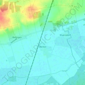
Name: Demker topographic map, elevation, terrain.
Location: Demker, Tangerhütte, Stendal, Sachsen-Anhalt, Deutschland (52.48647 11.83604 52.53327 11.89406)
Average elevation: 43 m
Minimum elevation: 32 m
Maximum elevation: 83 m
Thank you for supporting this site ❤️
Make a donation
Make a donation
Other topographic maps
Click on a map to view its topography, its elevation and its terrain.