
Penrith City Council topographic map
Interactive map
Click on the map to display elevation.
About this map
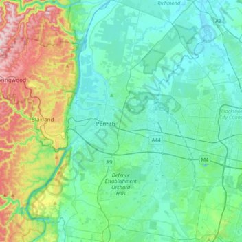
Name: Penrith City Council topographic map, elevation, terrain.
Location: Penrith City Council, New South Wales, Australia (-33.88319 150.58806 -33.61238 150.82350)
Average elevation: 97 m
Minimum elevation: 2 m
Maximum elevation: 442 m
Other topographic maps
Click on a map to view its topography, its elevation and its terrain.