
Gore District topographic map
Interactive map
Click on the map to display elevation.
About this map
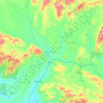
Name: Gore District topographic map, elevation, terrain.
Location: Gore District, Southland, Nouvelle-Zélande (-46.29885 168.70131 -45.79134 169.19829)
Average elevation: 203 m
Minimum elevation: 30 m
Maximum elevation: 827 m
Other topographic maps
Click on a map to view its topography, its elevation and its terrain.
Aiguille Rouge
Nouvelle-Zélande > Southland > Southland District > Fiordland Community
Aiguille Rouge, Fiordland Community, Southland District, Southland, Nouvelle-Zélande
Average elevation: 1,058 m
Mount Napier
Nouvelle-Zélande > Southland > Southland District > Fiordland Community
Mount Napier, Fiordland Community, Southland District, Southland, Nouvelle-Zélande
Average elevation: 752 m
West Plains
Nouvelle-Zélande > Southland > Invercargill City > West Plains
West Plains, Invercargill City, Southland, 9816, Nouvelle-Zélande
Average elevation: 7 m