
Thank you for supporting this site ❤️
Make a donation
Make a donation
Lac Blanc topographic map
Click on the map to display elevation.
Thank you for supporting this site ❤️
Make a donation
Make a donation
About this map
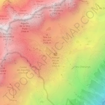
Name: Lac Blanc topographic map, elevation, terrain.
Average elevation: 2,310 m
Minimum elevation: 1,249 m
Maximum elevation: 2,937 m
Thank you for supporting this site ❤️
Make a donation
Make a donation
Other topographic maps
Click on a map to view its topography, its elevation and its terrain.
Mer de Glace
Frankrijk > Auvergne-Rhône-Alpes > Haute-Savoie > Chamonix-Mont-Blanc
Average elevation: 2,323 m