
Thank you for supporting this site ❤️
Make a donation
Make a donation
Aypate topographic map
Click on the map to display elevation.
Thank you for supporting this site ❤️
Make a donation
Make a donation
About this map
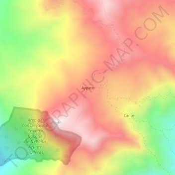
Name: Aypate topographic map, elevation, terrain.
Location: Aypate, Distrito de Ayabaca, Ayabaca, Piura, Perú (-4.71976 -79.59300 -4.67976 -79.55300)
Average elevation: 2,534 m
Minimum elevation: 2,056 m
Maximum elevation: 2,879 m
Thank you for supporting this site ❤️
Make a donation
Make a donation
Other topographic maps
Click on a map to view its topography, its elevation and its terrain.
Área de Conservación Privada Lagunas y Páramos de Andinos de San José de Tapal
Perú > Piura > Distrito de Ayabaca
Average elevation: 3,353 m