
College Hill topographic map
Interactive map
Click on the map to display elevation.
About this map
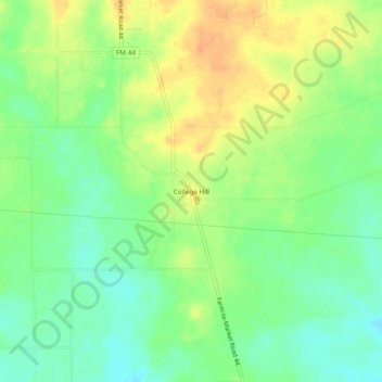
Name: College Hill topographic map, elevation, terrain.
Location: College Hill, Bowie County, Texas, United States (33.39567 -94.63298 33.43567 -94.59298)
Average elevation: 106 m
Minimum elevation: 89 m
Maximum elevation: 125 m
Other topographic maps
Click on a map to view its topography, its elevation and its terrain.
Nash
United States > Texas > Bowie County
Nash, Bowie County, Texas, 75569, United States
Average elevation: 104 m
Texarkana
United States > Texas > Bowie County
Texarkana, Bowie County, Texas, United States
Average elevation: 99 m
Hooks
United States > Texas > Bowie County > Hooks > Hooks
Hooks, Bowie County, Texas, 75561, United States
Average elevation: 114 m
New Boston
United States > Texas > Bowie County
New Boston, Bowie County, Texas, 75570, United States
Average elevation: 108 m
Redwater
United States > Texas > Bowie County
Redwater, Bowie County, Texas, 75573, United States
Average elevation: 87 m
De Kalb
United States > Texas > Bowie County
De Kalb, Bowie County, Texas, 75559, United States
Average elevation: 118 m